Category Archives: Environment

The Cathedral of the North

A Berlin story:

Outside the church a young woman pushes her bike up the cobblestoned incline that leads from the street to the door, passing by flower beds cut back for the winter and a slender post covered in words and images that, if you press on one of the small, silver buttons, will tell you the history of this building and its surroundings in a number of different languages. She doesn’t have time, and anyway, she has heard them before. Her bike is laden with shopping bags – in the basket and hanging from the handlebars – and she needs to get home. These are not supplies picked up on this square around the church; she had to ride to the supermarket and push her bike back. There is a shop on the corner, its neon sign suggesting you might find stacks of fresh produce in crates on the uneven pavement beneath. But look below and the pavement is bare. No fruit today or any day. Behind the windows, headless dummies model elegant clothes.

Continue reading

Postcards from the Edge, Part Nine: Karolinenhöhe

Over the next few months I will be walking around the outskirts of Berlin, starting each walk where I finished the last, until I complete a loop of the edge of the city. These walks will be written up for a new book project, and here on Under a Grey Sky I will publish some postcards from along the way…

I walk away from the lake, up a narrow path that cuts along the bottom of a gorge formed by two steep wooded hills, the floor covered in soggy leaves. This sense of enclosure evaporates as I cross the street, following a path into an open expanse of fields separated by high pathway avenues. These are the Karolinenhöhe Rieselfelder, part of a series of sewage irrigation fields built in the second half of the 19th century to process the waste of the rapidly growing, industrialising city. These fields were set up outside Berlin’s limits back then, although by now the shifting boundaries outwards mean that most are contained within the outskirts. Some were in operation up until the 1980s, and are now either farmed or have been turned into nature reserves.

Here, just south of Spandau, the traces are more visible the other former sewage irrigation fields I have crossed during my walk. Mostly grassed over, there are tell-tale fixtures and fittings that speak to its previous function. Concrete canals and drainage ditches. Steep-sided basins. Cobbled service roads, lined with trees. I have been here before and yet it is just as strange as on the first visit. In a way it is emblematic of the outskirts as a whole. Neither city nor country. Aspects of both. An in-between place. An edgeland place.

Most of all it reminds me of the polders on the banks of the River Oder, right where Germany meets Poland. To get to the river and the coloured boundary posts the path drops down from one dyke, crosses the dry polder, and then rises up to a dyke on the other side. All the way across you are aware that you are walking in a place that perhaps you shouldn’t. A place created by humans where, at any moment, the water’s could rise and you would be literally up to your neck in it. At Karolinenhöhe I have a similar, uneasy-yet-illogical feeling, and I find my pace quickens as I follow the raised service road in a diagonal line towards the very edge of Berlin, on the other side.

Rubha nam Frangach – Loch Fyne

Foreland1

The Rubha nam Frangach, or the French Farland, can be found a few miles south of the town of Inveraray on the western shore of Loch Fyne. The name of the promontory, and also the  cottage that was our home for a week over Easter, dates back to the eighteenth century and the height of the herring fishing industry on the loch. Back then, over 500 boats a day would be operating on Loch Fyne, and on the French Farland a small settlement of traders bought, cured and packed herrings from the local boats and took them back to France, returning with brandy, claret, silks and laces that they sold to the aristocracy of the region, including the Duke of Argyll in his castle a few miles up the road.

Continue reading

The Strange Beauty of the Anklamer Stadtbruch

Anklam1

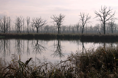
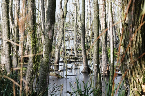
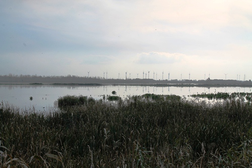
The strangeness began on the approach to Anklam, a massive collection of dead trees swamped at their base with water and surrounded by reeds, like something out of an apocalypse movie. It looked spooky and brutal, as if some cataclysmic event had taken place here, and so of course we stopped for a photograph.

Anklam2

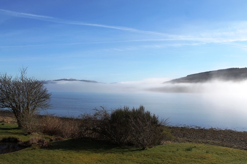
Half an hour later we were sitting in a minibus being driven through the streets of Anklam. We did not spend any time in the town, so we have to be careful not to rush to judgement, but it looked like a place that had seen better days. Many of the old Wilhelmine buildings were crumbling, but they looked more solid than the GDR-era plattenbau that looked ready to fall down at any moment. We were being taken by a guide from the city out into the Stadtbruch, a marshland and peat bog area on the edge of the inland sea that divides the mainland of Germany with the Baltic island of Usedom.

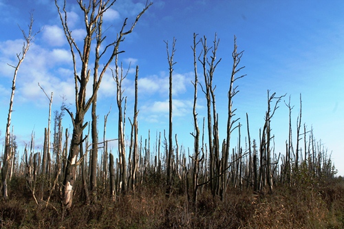
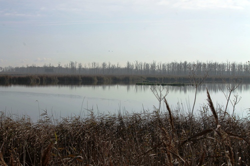
The walk was between two peat bog areas that had been drained for farmland but over the last twenty years allowed to return to something approaching a natural state. This is the case for a lot of the land between Anklam and the inland sea, and along the banks of the Peene river, which explained those dead trees we had come across earlier. We would see a lot more of them over the next couple of hours.

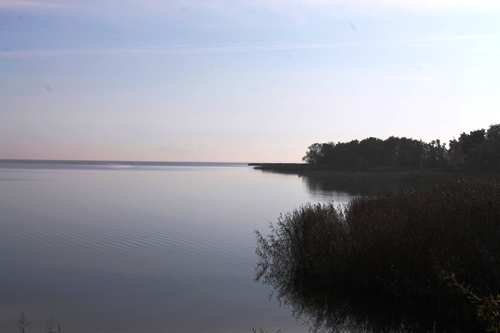
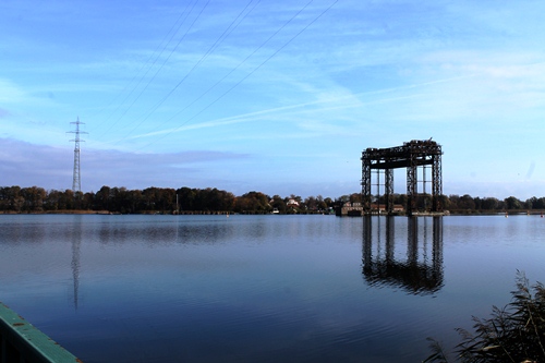
But first, before dealing with natural ruins, we started with some man-made ones. With a white-tailed eagle soaring overhead, we were looking across the water towards Usedom and the remnants of the old railway bridge that once transported the Berlin trains to and from the island, and which helped transform the fishing and farming communities into the seaside resorts I have written about on Under a Grey Sky over the past year. In 1945, with the end of the war approaching, the SS destroyed the bridge to prevent the approaching Red Army from making use of it, and ever since this particular line has been out of action. To get to Usedom now by train requires a more circular route, north and through the harbour town of Wolgast.

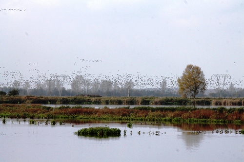
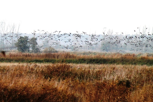
The long absence of the trains does have a benefit for the walkers and the birdwatchers who have discovered this strangely beautiful corner of Germany, for the raised embankment is high enough above the reclaimed bog to allow you to walk right through the middle of it without even getting the soles of your shoes wet. And so we walked, stopping to look and identify the wealth of birdlife that call this place home, as well as the traces of otters, dancing butterflies and one of the last remaining elm trees in Germany. Apparently the disease that wiped out the elm in Germany began a few kilometres to the south, and so this one survived… a remarkable story from a remarkable place.

Anklam3

Anklam4

Anklam5

Anklam6

Anklam7

Anklam8

Anklam9

Words: Paul Scraton
Pictures: Katrin Schönig

An Accumulation of Light

OLYMPUS DIGITAL CAMERA

By Julian Hoffman:

“Everything beckons us to perceive it,
murmurs at every turn…”
~ Rainer Maria Rilke

Hearing that a pair of eagle owls inhabited a rocky gorge on the plateau, we decided it was worth trying to see them hunting about the cliffs at dusk. First we explored the area in daylight, getting a feel for it before evening. The gorge began at the sea in a small cove where a few fishing boats were dragged up on to the beach and a handful of people swam in the shallows. Our friends couldn’t be tempted into the late September water and so they left us, trousers rolled up to our knees, walking the crystalline edge of the Black Sea. We’d only been in the surf a few minutes when they called us over, hushing us to come quietly to the pool of water they were standing by.

A squacco heron crouched on a stone at the edge of the pool. It was water lit, absorbing the mirrored light until it glowed. The bird’s back was draped in ochre and violet; its breast laced with lemon that bloomed towards the emerald edges of its eyes. It seemed to be the reflected emblem of the day, a distilled essence of light. The green and black lance of its bill was steady, and its eyes unwavering. It appeared to be lost in a trance but was peering for fish in the shallows, as still as the reflecting water. One of us must have shifted our weight, because suddenly it unfolded the white flags of its wings and glided away.

Continue reading

The Prora Nature Reserve, Rügen

Natur1

By Katrin Schönig:

A month or so ago, I spent a week on the island of Rügen. During my stay I took a walk in the Natur Reservat Prora and its treetop trail. Indeed, it was the idea of walking amongst the treetops that drew me there.

The Prora Nature Reserve is located between the Jasmunder inland sea – the Bodden – and Baltic bay known as the Prora Wiek, therefore bringing together different ecosystems. To protect these ecosystems, but at the same allowing people to experience the area, the park was closed off and you can only walk through it on a guided tour. The idea is that the Urwald (primeval forest) should be able to form itself again without human interaction. For example, dead wood is not taken away, and no new plants are planted. Yet, to still be able to enjoy this beauty of nature, the Naturerbe Zentrum of Rügen built a big wooden trail through the treetops.

Continue reading

The Landscapes of Berlin

Cover

What do we think of when we hear the word “landscape”? The first thought might involve hills and mountains or endless prairie fields and wide, wide rivers. It might involve sea cliffs and beaches, bleak moors or a Postman-Pat patchwork of land divided into neat parcels by high hedges. Landscape feels like it should be somehow “natural”, and it is tempting to idealise it as such, even though there are very few places – especially in Europe – that can truly claim to have been untouched by the influence of humankind. After all, we introduced the sheep that tore away the natural vegetation of the Welsh hills and we planted the corn that waves back and forth across the Mid-West. But still, more often than not the word is used to describe something different to the built-environment of the city, which is why I remain amazed when I find those corners of Berlin where it feels as if no other word will do.

Continue reading

The flickering of panic

cairnsmore-of-fleet-1

Cairnsmore of Fleet, Galloway, Scotland, February 2014

By Daniel Greenwood

A wading bird bursts from the bog. I watch its sharp wings cut into the wall of mist and descending treeline. I put my binoculars to my eyes and the bird is lost. The world has been reduced. All terrestrial life but for water, a few lichens, heather and wintry moor grasses has escaped. I have left behind oak woods overcome by rhododendron and cherry laurel, and Cairnsmore Burn choked by the former, its water crashing from the shadows. It was not right. Snowdrops still managed to create small rugs of white flowers and winter green leaves. Bluebells peeked through the leaf litter amongst them. Behold the denizens of Galloway’s oldest woods. Up here those are images in the mind. The life in the lap of the Cree estuary – the buses, postman, trees and gentle flowering plants are mere memory. The cover of Glenure Forest’s regimental spruce is the last notion of protection. It’s now up to willpower, my body and clothing. The path leads clear from 20 metres, visibility coming and going with cloud.

Continue reading

Working The View: relating the Yorkshire Dales landscape to its guardians

1_Matt

Wild Boar Fell at Dawn, chosen by Matt Neale, Area Ranger, Yorkshire Dales National Park Authority: “This is on one of my local runs. I get the train up to Kirkby Stephen early in the morning, run over Wild Boar Fell and back home, which is about 12 miles.”

Sarah Butler writes…

Working The View (www.workingtheview.co.uk) is a two-year collaboration between my brother (a landscape photographer who lives and works in the Yorkshire Dales ) and myself, exploring the relationship between the Yorkshire Dales landscape and its guardians. Working with 40 participants – from farmers to planners, from archaeologists to experts in peat restoration, water management and forestry – we asked them to choose their favourite view and tell us how and why they feel connected to this unique part of the world.

We’ve brought the results – a collection of gorgeous photos and fascinating insights into the passion and politics involved in maintaining and making a living from this landscape – together into a coffee table book (available from http://www.yorkshiredalesphotography.co.uk/wtv/products-page/) and a series of exhibitions throughout the Yorkshire Dales.

Continue reading

Loving our Lake, Lyn Padarn

We were sent details of a project initiated by our friends at Snowdonia Active, based in the Llanberis area of North Wales, which is inviting residents and businesses to join in to help improve the water quality of Lyn Padarn. The project will last a year, and will include numerous different activities to help identify and promote ways in which the community can take small steps to make big differences to help the lake and its wildlife.

Continue reading