

The rain started to fall as I waited for the car ferry to take me from Travemünde across the mouth of the river that gives the town its name to the village of Priwall, on the opposite bank. Priwall sits at the end of a peninsula that belongs to the city of Lübeck. The hinterland to which the peninsula is attached belongs to the state of Mecklenburg-Vorpommern. None of this really matters, except for the need to use the ferry if you want to stay within the limits of the Lübeck transport system. But from the end of the Second World War until early 1990 it did. Priwall was cut off by the inner-German border, surrounded by water and wire, and gazed down upon by watchtowers. The ferry I am waiting for was the only connection to West Germany, of which Priwall was a part. For the best part of half a century, the peninsula was – to all intents and purposes – an island.
Regular readers of Under a Grey Sky will know that I am fascinated by borders. I have spent much of the last couple of years exploring the traces of the border between East and West Berlin, now marked out by the Berlin Wall Trail. I make regular trips to the Oder, where Germany meets Poland. And for a new project, I have been exploring the Baltic coast – and what is the coast if not a border? – between two “lines in the sand”: the German-Polish border on the island of Usedom, and the older inner-German border at Priwall.
So I wanted to see it, but as the ferry dropped me on the other side of the Trave the rain was still falling and I wondered at myself and these ideas I get into my head. No matter, I was here now, and so I began to walk along the street that leads from the ferry ramp to Mecklenburg, and indeed is named for the neighbouring state. Although Travemünde is very much a holiday resort, Priwall on the opposite bank had the feeling of a real, lived in village, which is not to say there was much happening on a soggy Monday morning in March. The old-fashioned “Tante Emma Laden” (corner shop) was closed. As was the Italian restaurant. The campsite was empty. Cars passed by in ten minute intervals – the period between ferry arrivals – but otherwise I had the road to myself. Which was good, because it was not long before the pavement ran out and I was left to skip between the puddles on the curb.
It took about half an hour, maybe a little less, to reach the boundary, at the narrowest part of the peninsula where the inland sea bites into the dunes and the gap between the lagoon and the Baltic is only a couple of hundred metres. This was once a highly fortified border, part of the “Iron Curtain” that divided not only Germany but the continent of Europe. Now there were very few clues to the exact place of division, just a yellow sign with a line through the letters LÜBECK to indicate the city limits, and the start of a proper, well-paved bike path on the other side, obviously financed by the neighbouring state to the edge of their jurisdiction but no further. At the side of the road there was an information board, with a timeline of the division, and a heavy stone with a few words carved into its face.
NEVER AGAIN DIVIDED.
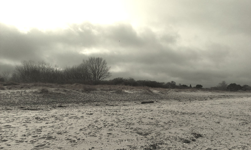
From the stone I followed a sandy path that led me up from the road between the former border strip – now wild and overgrown – and a row of weekend cottages firmly shuttered for the winter. In a matter of moments I had crossed the dunes and was down on the beach. Across the bay I could see the lighthouse and the highrise monstrosity that is the Maritim Hotel in Travemünde. Accessed by the ferry, this had long been a beach for outsiders… the end closest the mouth of the river reserved for dogs and here, where I was standing, reserved for nudists. For forty years West Germans who believed in the free body culture bathed naked beneath the watchful eyes of East German border guards. Twenty five years on, I had the place entirely to myself.
I walked down to the water’s edge and looked back up the sands towards the dunes. I was trying to pinpoint the exact spot where the border once stood, but it was impossible. No remnants of the fortifications. No memorial stone. No signpost. A few weeks ago I discovered a similar scene on Usedom, where the border between Poland and Germany is very much real, but from the water’s edge there is nothing to hint at its location on the sands. As I stood, alone on the beach, guessing at the point where East Germany once met West, the sun decided to come out. Only for a second. And then the clouds skidded over again, and by the time I started to follow the shore back around the headland to the ferry, the rain had begun to fall once more.
Words & Pictures: Paul Scraton

Pingback: A year to elsewhere and back | Under a Grey Sky
Nice piece. My late father was stationed at Priwall and Travemunde in the war, as part of an RAF disarmament team. Both places were home to classified German research into seaplanes etc. and were targets for the Allies’ T Force. Just been to the PRO reading the daily log. It’s a fascinating time and place.